Showing posts with label Colorado River. Show all posts

Friday, May 30, 2014

Birding Walk - May 28th, 2014


***


We went for a birding walk in Grand Junction east of 29 Rd. along the Colorado River and then down by Connected Lakes near the Audubon Center. Here are some pictures and video clips from that walk. 


View from the trail.


An osprey next to its nest on a telephone pole next to the path.


The same osprey in a tree not far from its nest.


A Bullock's Oriole, right across the trail from the osprey nest. 
We spotted a Western Tanager just before this bird appeared.


***


An American Avocet far off on the other side of the water.


This little rabbit was calm, and posing for the camera.


***


A stink bug on the path.


A second Bullock's Oriole.


***

Next, we made our way over to the Connected Lakes Audubon Trail.


Of course there were a lot of Mallard Ducks to be seen.


Canada Geese with their young.


***


Large portions of the trail were flooded due to recent rains.


View from the trail.


Aquatic insects along the trail.


Some sort of hanging, pupating larvae.
They look somewhat like ladybird beetle larvae.


***


A wolf spider mama carrying her babies on her back.


***


***


American Coots, a muskrat, and geese.


Another view from the lake.


***

Thursday, May 22, 2014

Grand Junction Bull Snake


***


This bull snake was discovered in Grand Junction, Colorado,
in the parking lot of a busy shopping area on May 20th, 2014.
It was caught to be released in a safer location.


Approximately 3 ft. long, it was a nice looking specimen.
It was also relatively calm and easy to handle.


Video of the release of the snake, near the Colorado River.


***

Sunday, February 23, 2014

Blue Heron Trail Sunset


*


 I rode the bike home for the first time in a while this evening. Here are a couple of pics of the sunset from the Blue Heron Section of the Colorado River Trail in Grand Junction, Colorado.


***

Tuesday, December 17, 2013

Hoar Frost Alongside the Colorado River

*

The hoar frost in the trees and blowing in the breeze created a beautiful scene this morning on the Blue Heron Section of the Colorado River Trail in Grand Junction, Colorado this morning.


UPDATE: My friend Scott brought up the question about whether this was hoar frost or rime ice. I'm from Yuma, Arizona; I don't know! Anyway, I never knew what exactly hoar frost was until about a week ago when the Grand Junction Sentinel ran an article with a picture of a hawk perched on a tree covered in hoar frost. I'd read the term in books, but like many other wintery things, I'd never matched the term with the actual event in my brain. It helps to have an article with pictures.


***

Saturday, May 04, 2013

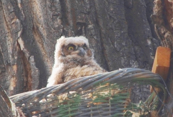
Great Horned Owls at the Connected Lakes

*


Two of the owlets left the nest today.


One was still in the nest this afternoon.


Look at those feathers!
They needed them. It was windy, as you'll see below.


The video above does get close up towards the middle.


*


O.o


Yawn...


*


Link to pictures of the 2012 owlets

and another link to the 2011 owlets.


***

Saturday, March 23, 2013

March Birding 2013

***

My friend Scott and I went out birding today. We didn't see anything spectacular, but we did have a good time. Today I was experimenting with using my cell phone to take pictures (and video) through the binoculars. The picture of the great horned owl and the video of the beaver were taken that way.


This flicker was the first bird (other than geese and coots) spotted.
It was a slow day for birds on the Connected Lakes Trail.


*


 The great horned owl was avoiding the paparazzi.
There will be babies to see soon enough.

*

Scott was driving, and yet somehow managed to spot a beaver on the shoreline of the Colorado River west of the Hwy 340 Bridge south of Fruita. I wasn't able to get any good shots of the beaver on the riverbank, but I did manage to get a decent video by pairing up my cell phone with my binoculars:

Video #1:


Video #2:


Videos (above): Beaver swimming in the Colorado River.


***

Saturday, February 09, 2013

View from Okagawa Farms

*

Click on pics to view full-size.


 Looking east over the 29th Street Bridge in Grand Junction.
Mt. Garfield and Grand Mesa off in the distance.


 The Colorado River, Mt. Garfield, and the Bookcliffs.


These pictures were taken from the parking lot 
at Okagawa Farms on Feb. 9th, 2013

***

Sunday, November 18, 2012

Palisade Migratory Labor Camp

*


View of Mt. Garfield from Riverbend Park in Palisade.


An early photo of the Palisade Labor Camp


An explanation of the Palisade Labor Camp (text below):

"You are standing on the site of the former Palisade Migratory Labor Camp. The camp was established by the U.S. Department of Agriculture in 1941 in an effort to provide decent housing for migratory farm labor laborers. 

Since the early 1900's, local peach growers and packers in the Grand Valley have used temporary labor to help during the peach harvest. As more orchards were established, more and more labor was required. Thousands of people would come to the Grand Valley for two weeks a year to help pick, sort, and pack and ship peaches. 

The Palisade Migratory Camp was built for the laborers and their families to improve living conditions. Prior to the Labor Camp these groups would camp all over the Grand Valley during their stay. In 1948, the federal government sold the Labor Camp to several local agricultural commodity groups who immediately transferred it to the Palisade Peach Board of Control. The Board of Control managed the Camp until it was closed in the early 1960's. There are still several old building foundations on this site, but most of the buildings were sold to growers and moved onto their property."


A picture of one of the original buildings


The cement slabs along the trail are all that remain.
The view looking west.


The view looking northeast.


A map of the old labor camp as it stood from 1941-1961.


***